
TE HIKU WATER STUDY
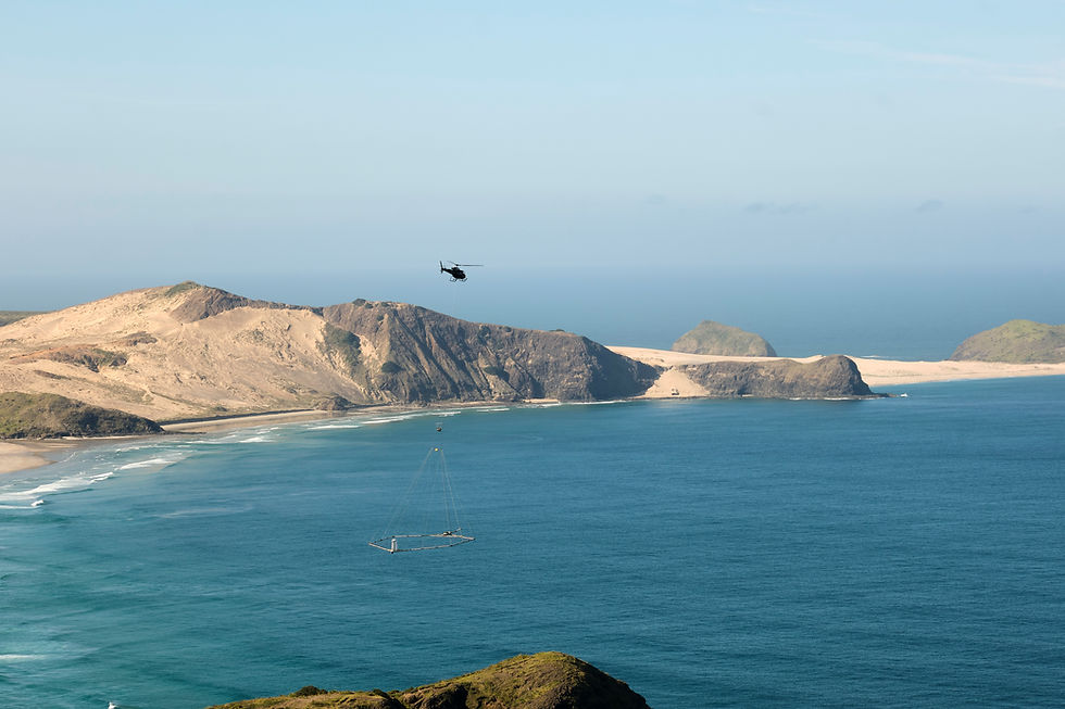
Helicopter flying over the Northland coast during the Te Hiku aerial aquifer survey.
Credit: Christian H. Sodemann, Senior Field Manager, SkyTEM
Te Hiku Water Study animation
The Te Hiku Water Study in Northland is a scientific investigation to find out more information on the Aupōuri aquifer. This project is backed by the Te Hiku iwi, community and councils, because knowing more about the aquifer will help us to identify the best ways to balance environmental protection, the increased demand for water, and events such as droughts.
About the Te Hiku Water Study
UPDATE APRIL 2026
Publicly available reports are available via Earth Sciences New Zealand (formerly GNS Science) library:
Santamaria Cerrutti, M.E.; Mourot, F.; Westerhoff, R.S. 2021 Inventory of available data for
hydrogeological investigations of the Aupōuri Peninsula, Northland. Aqua Intel Aotearoa report
2021/05 (GNS Science consultancy report 2021/98). 54 p. https://doi.org/10.21420/JQJR-
CQ20
Westerhoff, R.S.; Herpe, M.; Rawlinson, Z.J.; Sahoo, T.R.; Kass, A. 2024 Hydrogeological
mapping of the Aupōuri Peninsula, Northland: SkyTEM processing and resistivity models. Aqua
Intel Aotearoa report 2024/01; (GNS Science consultancy report 2024/08). 117 p.
https://doi.org/10.21420/ZEE1-VN08
Westerhoff, R.S.; Herpe, M.; Rawlinson, Z.J.; Santamaria Cerrutti, M.E.; Brakenrig, T.;
Cameron, S.G. 2022 Feasibility of aquifer investigation with the SkyTEM method in the Aupōuri
Peninsula, Northland. Aqua Intel Aotearoa report 2021/06; (GNS Science consultancy report
2021/99). 85 p. https://doi.org/10.21420/ZRKT-FT95
Westerhoff, R.S.; Herpe, M.; Sahoo, T.R.; Santamaria Cerrutti, M.E.; Strogen, D. P.; Rawlinson,
Z.J.; Narvaiza, M. 2025 Hydrogeological mapping of the Aupōuri Peninsula, Northland:
interpretation of SkyTEM resistivity models. Aqua Intel Aotearoa report 2025/04; (GNS Science
consultancy report 2025/89). 93 p. https://doi.org/10.21420/B2ZY-TD33
UPDATE: AUGUST 2024
We already know some information about the Aupōuri aquifer (e.g., from groundwater drilling) but we want to fill in information gaps. Knowing more about the aquifer will help us to identify the best ways to balance environmental protection, the increased demand for water, and events such as droughts.
The project has come from the Te Hiku community, and their strong desire to understand their water resources better. Following a PGF feasibility study and in response to increased water demand and recent droughts, the local community want improved data on the aquifer. This idea became part of an Aqua Intel Aotearoa project on water studies in Northland.
The project team is making progress with the analysis of data about the Aupōuri aquifer.
-
In late 2022, SkyTEM equipment was used to collect airborne electromagnetic data. This data was collected along flight lines 200 - 300 m apart (Figure 1).
-
During August 2022 data processing and resistivity modelling was completed on the data, providing resistivity model information spaced 25 m apart along the flight lines, and down to an average depth of 350 m.
-
Current work is well underway to understand the hydrogeological information contained within these resistivity models. This requires expert analyses supported by datasets such as geological maps and borehole logs. Interpretation includes mapping locations of saline groundwater, classifying the geological formations based on their water storage and transmission capacity and identifying shallow features.
-
Before the end of 2025 these elements will be combined together to create an overall 3D subsurface picture, which can be used to model groundwater resources. The project will produce a series of hydrogeological maps and a much-improved 3D hydrogeological model for the peninsula.
-
The project team is currently underway with scoping the numerical groundwater modelling task, in collaboration with the Te Hiku Project Team, which will be the final component of the planned AIA programme work in the area.
Figure 1: Location of AEM flights in Te Hiku. Aupouri Aquifer management Zones are depicted in blue and the survey area is depicted in red.
Who is supporting the mahi
The $3.3 million research project is largely funded through Aqua Intel Aotearoa. AIA is a collaboration between Kānoa (the delivery arm of the Provincial Growth Fund) and GNS Science. Co-funding organisations include Northland Regional Council, Far North District Council, and Te Aupouri. Aqua Intel Aotearoa is doing the mahi, and a local project team oversees the study.
What we want to learn
We will never know everything about the aquifer, but this study will give us a better understanding of:
-
what the aquifer looks like (e.g. depth, extent, geology)
-
how the aquifer is connected to wetlands, lakes and streams
-
the boundary between groundwater and seawater (risk areas for salt-water intrusion)
-
how groundwater recharges.
The data was received from SkyTEM in early 2023. and processing has resumed. The project team aim to have outcomes of available by early-mid 2024.
For further information:
-
Speak with any member of the project team.
-
Email us: info@aquaintel.co.nz
-
Download Factsheet I (Te Hiku Water Study - April 2022).
-
Download Factsheet II (Te Hiku Water Study - September 2022).
-
Use the buttons below to send an enquiry or visit our Facebook page.
-
A copy of the presentation from the 21 July 2021 (Kaitaia) and 22 July 2021 (Pukenui) meetings is available here.

Aupōuri aquifer
Why do you need to map the aquifer?
The need to protect environmental flows, an increased demand for water, and recent droughts mean we need to get more information to make more informed decisions about balancing water use with environmental protection.
What is the Aupōuri aquifer?
The Aupōuri aquifer is an area of natural underground water storage where water flows into the aquifer between rocks, sediment and shell beds. Water can be drawn from the aquifer, and it also flows out into surface water (e.g., streams, lakes).
This project aims to find out more details about what the aquifer looks like (e.g. depth, extent, geology); how and where the aquifer is connected to wetlands, lakes and streams; identify the boundary between groundwater and seawater (e.g., risk areas for salt-water intrusion) and find out more about how groundwater recharges.
Where is the Aupōuri aquifer located?
The Aupōuri aquifer lies approximately between Parengarenga Harbour, Rangaunu Harbour, and Ahipara Bay. The full extent of the aquifer is one of the questions for the survey to answer.
Why do we need to know more about the aquifer?
Knowing more about the Aupōuri aquifer will help identify the best ways to manage the aquifer, including balancing environmental protection, the increased demand for water, and events such as droughts.
Aerial Electromagnetic Surveying
For information
For information on AEM please check out our AEM: Frequently Asked Questions Section.
Te Hiku Water Study
Where did the project originate?
The project idea came from the Te Hiku community and is now part of water studies in the Northland Region being conducted by Aqua Intel Aotearoa (AIA), a collaboration between Kānoa (the delivery arm of the Provincial Growth Fund) and GNS Science.
Who is responsible for the project?
The project is being overseen by the Te Hiku Water Study Project Team, which includes representatives of iwi, landowners and local and regional councils.
Who is on the project team?
The project team oversees the study, while the technical work will be undertaken by GNS Science staff and contractors. The representatives from each project partner are:
-
Ngai Takoto: Wallace Rivers, Craig Wells
-
Ngati Kuri: Walter Wells
-
Te Aupōuri: Penetaui Kleskovic
-
Te Rarawa: George Riley
-
Landowners: Wendy Thomas, Ian Broadhurst
-
Ratepayers Association: Eric Wagener
-
AIA: Jane Frances, Ben Pasco
-
GNS Science: Rogier Westerhoff and Zara Rawlinson
-
Northland Regional Council: Susie Osbaldiston, Jason Donaghy
-
Far North District Council: Shane Storey, Kennith Lewis
Who is funding the project?
The $3.3 million project is mainly funded through AIA.
AIA is contracting an Australian-based AEM surveying company called SkyTEM to undertake the survey. SkyTEM Australia have undertaken similar work in Hawke’s Bay and Waikato regions.
Project outcomes
What will the information be used for?
This will guide decisions on environmental protection, economic growth and development, resource consents, water management, and water availability for the local community.
Who can access the research information?
The findings from the research will be used by councils in guiding resource management, setting water policies and allocations. The information used by the councils will be publicly available. Access to the raw data will be managed by AIA (and after AIA’s work programme is completed, GNS Science), councils and tangata whenua.
What other work is AIA undertaking in Northland?
In addition to the aerial surveying, work is underway monitoring surface water flow in rivers and streams across Northland. Specialists are looking at the potential to harvest and store high surface water flows for use in times of water shortage. In addition, planning is underway to find out more about the Pouto peninsula groundwater, through groundwater drilling.
What if I have more questions about the Te Hiku Water Study?
Please talk to a member of the project team, contact us via email, or submit an online form.

Photo credit:
SkyTEM Australia
Get in touch with Aqua Intel Aotearoa to learn more about our projects or ask a question.
